Tibble Fork Reservoir sits within American Fork Canyon. The water source for this impoundment is the American Fork River and its many tributaries, including Silver Creek and Tibble Fork Creek.
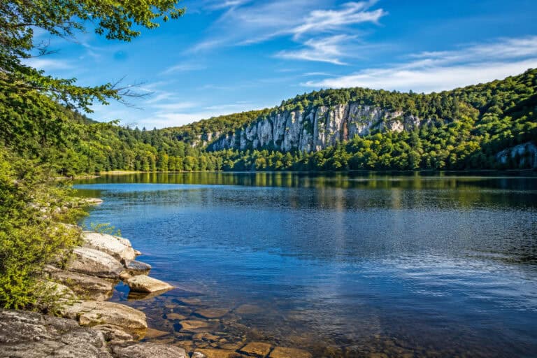
At 6,392 feet in elevation, this body of water, surrounded by mountain peaks in the Uinta-Wasatch-Cache National Forest, is a popular destination for hiking, fishing, mountain biking, horseback riding, and canoeing.
The reservoir is 48 miles from Provo, 53 miles from American Fork, and 65 miles from downtown Salt Lake City.
Created to collect water for local irrigation purposes in the mid-1960s, Tibble Fork Reservoir has become a popular destination for those who enjoy outdoor activities in the American Fork Canyon Region.

Just 7.5 miles north of Mount Timpanogos as the eagle flies, this US Forest Service area is known for spectacular views and great photographic vistas.
Spruce, douglas fir and pine evergreens join with oaks and meadows to surround the reservoir.
Those planning for a summertime visit should be prepared for full parking lots and avoid illegal parking. The expanded parking lot along the reservoir is known to fill early on weekends.
Rangers with the Uinta-Wasatch-Cache National Forest and the Utah County Sheriff’s Office have increased their enforcement efforts for those who illegally park.
Those who cannot find a parking space should consider visiting picnic areas southwest of the reservoir.
History
Once known as an area for lead, silver, and gold mining, locations along the American Fork River upriver from Tibble Fork Reservoir have contained sediments from these activities.
Local irrigation needs encouraged officials to impound a portion of the river in the mid-1960s.
The original impoundment was 9.6 acres, though rehabilitation efforts started in 2016 led to the expansion of the reservoir’s surface area to 21.6 acres.
These improvements also included the creation of an expanded parking area, a swimming beach, and an area to launch hand-propelled watercraft.
Activities
Tibble Fork Reservoir is a popular location for fishing, hiking, biking, camping, canoeing, and kayaking.
Swimming:
- Swimming is allowed at Tibble Fork Reservoir.
- Swimmers who wish to take a dip in this reservoir should check Utah’s Department of Environmental Quality to learn of advisories for waterborne pathogens.
- A sandy beach area has recently been added for summertime sunbathers and swimmers.
Boating:
- No motor boats of any kind are allowed, including electric motors.
- Smaller, hand-propelled boats are permitted at Tibble Fork Reservoir.
Paddling:
- Canoeing, paddle boarding, and kayaking are permitted within the reservoir.
Fishing:
- Common species found are rainbow trout, brown trout, cutthroat trout, and brook trout.
- Other species include the arctic grayling.
Camping:
Granite Flat Campground, along Deer Creek, less than 2,000 feet northwest of the reservoir, provides camping opportunities. The season usually runs from early June through mid-October.
Note to campers: The nearest telephone is located five miles away from this campsite. No potable water or electricity is available.

Hiking At Site:
- Lower Mill Canyon Trail: An 11.2-mile loop trail with an elevation gain of 2,276 feet, this moderately challenging route that is usually accessible between May and October offers opportunities for birding. Cross-country skiers access this trail during the winter.
- Tibble Fork Loop Trail: A dog-friendly trail that spans 3.8 miles, including a loop around the reservoir, with an 800-foot gain.
- Tibble Fork Trail: This 4.8-mile round-trip trail is moderately challenging, with an elevation gain of 1,095 feet, and is popular with hikers, runners, and dog walkers.
Hiking Nearby:
- Silver Lake Trail: Located on the northern side of Silver Lake Flat Reservoir, an impoundment of Silver Creek that is a few miles north of Tibble Fork, this 4.7-mile round-trip hike up to Silver Lake has a 1,433-foot elevation gain.
Off-Highway Vehicle Trails:
- Tibble Fork to Midway OHV Trail: A 31.5-mile, moderately challenging out-and-back trail with an elevation gain of 5,085 feet, usually available between May and October; no winter access.
Winter Activities:
- Ice Fishing
- Snowshoeing
- Cross-Country Skiing
- Sledding
- Snow Tubing

Other Activities:
- Timpanogos Cave is a popular stop on the way to Tibble Fork Reservoir. (State Route 92)
Wildlife
- In addition to deer, visitors have encountered moose in the area of the reservoir.
- Bird and nature watching are popular activities.
Picnic Areas near the Reservoir
- Echo Picnic Area: Day-use area along Utah Highway 144, that is 2.3 miles southwest of the reservoir, along the American Fork River, with fishing access and caving opportunities near the small Echo Reservoir.
- Martin Picnic Area: Day-use area along Utah Highway 144, that is 1.4 miles southwest of the reservoir, along the American Fork River, with fishing access.
- Mile Rock Picnic Area: Day-use area along Utah Highway 144, that is 1.1 miles southwest of the reservoir, along the American Fork River, with fishing access.
- Roadhouse Picnic Area: Day-use area along Utah Highway 144, that is 2.2 miles southwest of the reservoir, along the American Fork River, with fishing access and caving opportunities.
Access Points
- The primary access to Tibble Fork Reservoir is via Utah State Highway 144 (North American Fork Canyon Road), a former US Forest Service Road.
- Vehicle access is usually possible from May through October.
- Winter access may require a snowmobile, snowshoeing, or cross-country skiing.
More Lakes in Utah:
Lake Guides:
Trails in Utah:
Parks in Utah: